9 Scenic Hiking Routes in Switzerland for Every Level
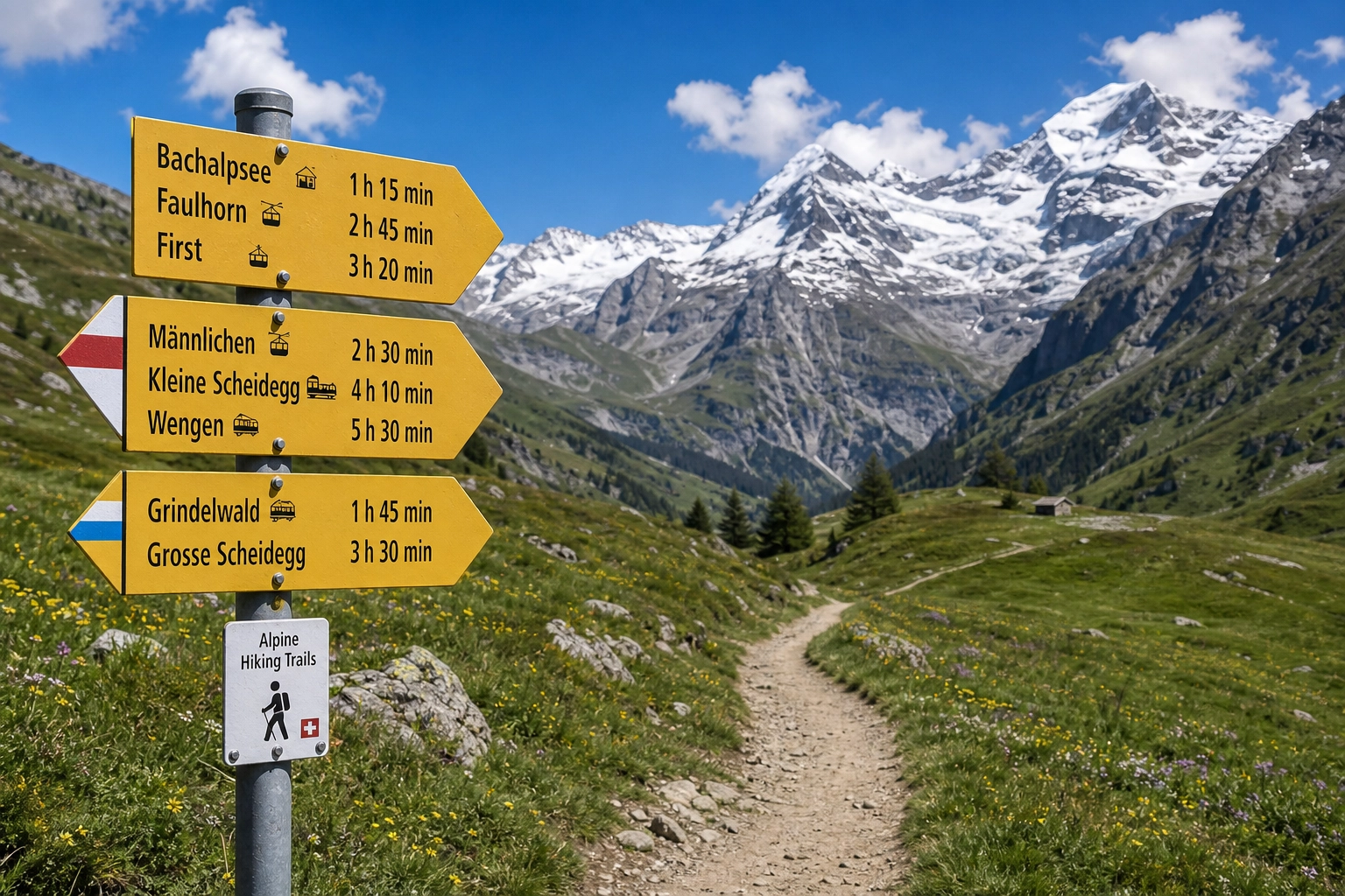
Switzerland’s trail network is staggering. With over 65,000 kilometers of meticulously maintained paths cutting through alpine meadows, glacier-carved valleys, and dramatic ridgelines, it is arguably the most robust hiking infrastructure in the world.
Yet, the sheer volume of options—and the imposing reputation of the Alps—can make planning a trip intimidating. A common misconception is that hiking here requires elite mountaineering skills, expensive specialized gear, or a massive travel budget. The reality is far more accessible. The Swiss have engineered their mountains so that a casual walker can access the same breathtaking panoramic views as a seasoned alpinist, often aided by an efficient network of funiculars, cable cars, and high-altitude post buses.
Whether you are a solo traveler testing your first mountain trail, a digital nomad squeezing in a weekend adventure, or a highly experienced trekker seeking serious elevation, there is a route designed for your exact capabilities.
This guide breaks down nine of the most rewarding hiking routes in Switzerland across three distinct difficulty levels. We will also cover how to decode the local trail marking system, the logistics of mountain accommodation, and how to structure your basecamp for the best possible experience.
Decoding the Swiss Trail Grading System
Before you step onto the dirt, you must understand how Switzerland categorizes its trails. According to SchweizMobil, the national network relies on a strict color-coded system. Ignoring these markers is the fastest way to find yourself on terrain you are not prepared to navigate.
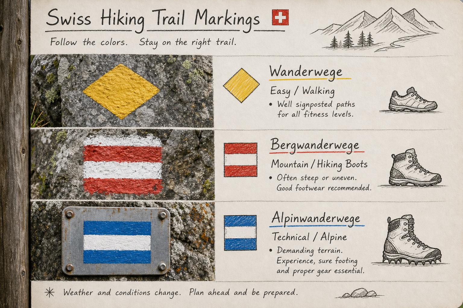
- Yellow Markers (Wanderwege / Hiking Trails): These are accessible, entry-level paths. They are often wide, relatively flat, and sometimes paved or composed of hard-packed gravel. You can walk these in standard athletic shoes. They do not require technical mountain experience.
- Red-White-Red Markers (Bergwanderwege / Mountain Trails): This is the standard alpine hiking tier. These trails are steeper, narrower, and often traverse uneven, rocky, or root-heavy terrain. They require dedicated hiking boots with good traction, moderate physical fitness, and an awareness of changing mountain weather.
- Blue-White-Blue Markers (Alpinwanderwege / Alpine Routes): These are highly technical, demanding routes. They frequently involve scrambling over loose scree, crossing snowfields or glaciers, and navigating exposed ridgelines equipped with fixed cables or ladders. You need serious alpine experience, head-for-heights, and sometimes specialized gear (helmets, harnesses) to tackle these safely.
Quick Comparison of the 9 Featured Routes
| Route Name | Region | Distance | Elevation Gain | Difficulty | Best For |
|---|---|---|---|---|---|
| 1. The 5 Lakes Walk | Zermatt | 9.3 km | 241 m | Beginner | Iconic Matterhorn reflections |
| 2. Oeschinensee Loop | Kandersteg | 8.5 km | 400 m | Beginner | Stunning turquoise glacial water |
| 3. Val de Bagnes Trail | Liddes | 12.0 km | 350 m | Beginner | Quiet valleys and basecamp access |
| 4. The Eiger Trail | Grindelwald | 6.0 km | 700 m (Descent) | Intermediate | Close-up views of the North Face |
| 5. Schynige Platte | Interlaken | 16.0 km | 800 m | Intermediate | Classic ridge endurance walking |
| 6. Aletsch Panorama | Valais | 12.0 km | 450 m | Intermediate | Walking alongside Europe's largest glacier |
| 7. Hardergrat Trail | Interlaken | 24.0 km | 1,500 m | Advanced | Extreme exposure and ridge traversal |
| 8. Saxer Lücke | Appenzell | 16.0 km | 900 m | Advanced | Dramatic limestone cliffs and spires |
| 9. Tour des Combins | St. Stephan | 15.0+ km | 1,200+ m | Advanced | Multi-day border-crossing preparation |
Beginner-Friendly Routes: High Reward, Low Risk
These trails are characterized by minimal technical difficulty, manageable elevation profiles, and excellent proximity to transport hubs. They are perfect for families, budget-conscious backpackers looking for a half-day excursion, and anyone acclimatizing to the altitude.
1. The 5 Lakes Walk (5-Seenweg), Zermatt
If you want the quintessential view of the Matterhorn reflecting in a pristine alpine lake without having to suffer through a grueling ascent, the 5 Lakes Walk is unmatched.
- Distance: 9.3 km (Loop)
- Elevation Gain: 241 m
- Trail Type: Red-White-Red (but falls on the easier end of the spectrum)
- Starting Point: Blauherd Cable Car Station
The Experience:
The trail links five distinct alpine lakes: Stellisee, Grindjisee, Grünsee, Moosjisee, and Leisee. Stellisee is the crown jewel, offering a mirror-perfect reflection of the Matterhorn if you arrive early enough in the morning before the wind disturbs the water’s surface. The path is well-trodden and easy to follow, making it a staple for international visitors.
Local Tip: Skip the expensive mid-mountain restaurants. Pack a lunch from a local bakery in Zermatt and eat at Leisee, which features a designated picnic and barbecue area with free-to-use wooden loungers.
2. Oeschinensee Panorama Loop, Kandersteg
Lake Oeschinen (Oeschinensee) is frequently cited as the most beautiful lake in the Alps. Fed by glacial brooks from the surrounding 3,000-meter peaks, its striking turquoise color contrasts sharply with the dark rock faces that drop vertically into the water.
- Distance: 8.5 km
- Elevation Gain: 400 m
- Trail Type: Red-White-Red
- Starting Point: Kandersteg Gondola Top Station
The Experience:
Instead of just walking the wide, flat path from the gondola to the lake shore, take the higher panorama trail (Heuberg). This route elevates you above the tree line, providing sweeping aerial views of the lake basin before winding back down to the water’s edge, where you can rent a rowboat or bravely swim in the frigid glacial runoff.
Local Tip: Because this is one of the most popular hikes on AllTrails, it can get congested. Arrive on the first gondola of the day, or hike up from the valley floor (adding 1.5 hours and 400m of elevation) to avoid the lift fees entirely.
3. Val de Bagnes Discovery Trail, Liddes Region
While the Bernese Oberland gets the lion’s share of tourist traffic, the Val de Bagnes region offers a quieter, more communal mountain experience deeply rooted in local Swiss culture.
- Distance: 12 km (Out and back options)
- Elevation Gain: ~350 m
- Trail Type: Yellow / Red-White-Red
- Starting Point: Liddes / Val de Bagnes
The Experience:
This area serves as a strategic launchpad for exploring the surrounding peaks, including access routes toward Mont Blanc. The trails here wind through traditional farming hamlets, dense pine forests, and open pastures ringing with cowbells. It lacks the overwhelming crowds of Grindelwald, allowing for a highly peaceful hike.
Local Tip: This region is the home of Ski Hostel, a community-driven adventure lodge. It is highly popular with solo travelers and digital nomads who prefer a “home away from home” atmosphere. Using a basecamp in Liddes gives you direct access to over 250 kilometers of trails, plus organized border-crossing excursions into Aosta, Italy, for a mid-week change of scenery.
Intermediate Routes: Building Endurance and Elevation
Intermediate trails introduce steeper gradients, longer distances, and higher altitudes. You will need proper footwear, layered clothing for rapid weather shifts, and enough water for a full day of exertion.
4. The Eiger Trail, Grindelwald
The North Face of the Eiger is legendary in mountaineering history—a massive, imposing vertical wall of limestone and ice. The Eiger Trail lets you hike directly beneath this iconic face without needing climbing gear.
- Distance: 6 km (Point-to-point)
- Elevation Profile: 700 m descent, 150 m ascent
- Trail Type: Red-White-Red
- Starting Point: Eigergletscher Station
The Experience:
Taking the hyper-modern Eiger Express cable car to Eigergletscher, you begin right at the base of the rock wall. The trail contours tightly along the mountain, offering dramatic, neck-craning views straight up the North Face. To your right, you have unobstructed panoramic views of the Grindelwald valley. The route is mostly downhill, finishing at the Alpiglen train station, but the steep descent requires strong knees and hiking poles.
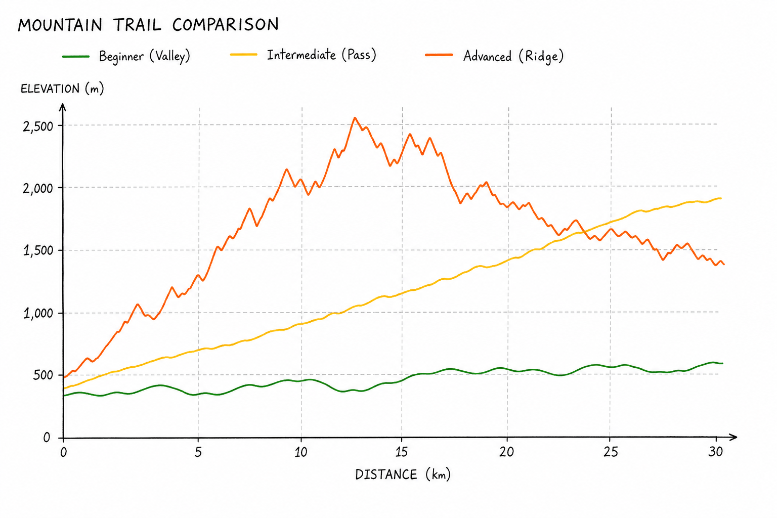
5. Schynige Platte to First (via Faulhorn)
This is a classic Swiss ridge walk, frequently appearing on curations like the 50 Best Hikes in Switzerland. It demands stamina but rewards you with constant, shifting views of the Eiger, Mönch, and Jungfrau massifs.
- Distance: 16 km (Point-to-point)
- Elevation Gain: 800 m
- Trail Type: Red-White-Red
- Starting Point: Schynige Platte
The Experience:
After taking a nostalgic cogwheel train to Schynige Platte, the trail undulates across alpine meadows before climbing steeply to the Faulhorn summit. At 2,681 meters, the Berghotel Faulhorn is one of the oldest mountain inns in the Alps and a perfect spot for a coffee break. The descent toward Grindelwald First takes you past the dark, reflective waters of Lake Bachalpsee.
Local Tip: Logistics are critical here. You are starting and ending at different transport nodes. Ensure you know the time of the last gondola down from First, otherwise you will add an exhausting two-hour downhill slog to Grindelwald to an already long day.
6. Aletsch Glacier Panorama Trail
The Great Aletsch Glacier is a colossal river of ice, stretching over 20 kilometers and containing billions of tons of frozen water. Walking alongside it is a humbling reminder of the geological scale of the Alps.
- Distance: 12 km
- Elevation Gain: 450 m
- Trail Type: Red-White-Red
- Starting Point: Fiescheralp / Bettmerhorn
The Experience:
The panorama path hugs the mountain contour high above the glacier. The trail is wide and well-engineered, consisting mostly of large, flat flagstones. Because you are hiking parallel to the ice flow, the scenery is relentless and dramatic for hours on end.
Local Tip: Glacial microclimates are unpredictable. Even on a hot summer day in the valley, the wind coming off the ice field can drop the ambient temperature significantly. Pack a high-quality windbreaker and a lightweight mid-layer.
Advanced Routes: Technical Terrain and Extreme Exposure
These routes fall strictly into the difficult Bergwanderwege or Alpinwanderwege categories. They feature severe exposure, technical scrambling, and significant physical output. Do not attempt these if you are unfit, afraid of heights, or if the weather forecast predicts rain.
7. The Hardergrat Trail, Interlaken
The Hardergrat is perhaps the most infamous day hike in Switzerland. It is a grueling, highly exposed traverse along a razor-thin ridgeline high above Lake Brienz.
- Distance: 24 km (Point-to-point)
- Elevation Gain: 1,500 m (Over 3,000 m of total elevation change)
- Trail Type: Blue-White-Blue (Alpine)
- Starting Point: Interlaken (Harder Kulm)
The Experience:
For much of the day, you are walking on a grassy ridge that is sometimes no wider than a dining room table, with sheer, near-vertical drops on both sides. The physical endurance required is massive, but the psychological toll of constant exposure is what breaks many hikers.
Crucial Warning: Never attempt the Hardergrat if the grass is wet. The steep slopes become frictionless slides. There are also no natural water sources on the ridge; you must carry a minimum of 3 to 4 liters of water. You are also racing the clock to reach the Brienzer Rothorn train before it stops running for the day.
8. Saxer Lücke and Fälensee, Appenzell
The Alpstein massif in the Appenzell region looks entirely different from the rest of the Swiss Alps. Instead of snow-capped granite pyramids, you find jagged, pale limestone spires that look like dragon teeth bursting from the green earth.
- Distance: 16 km
- Elevation Gain: 900 m
- Trail Type: Red-White-Red (bordering on Blue-White-Blue in sections)
- Starting Point: Hoher Kasten
The Experience:
Following a cable car ascent to Hoher Kasten, you traverse a long, rugged geological fault line. The highlight is the Saxer Lücke, a dramatic visual where the earth simply drops away into a sheer cliff face. The hike eventually descends into a steep, narrow valley to the shores of Fälensee, a fjord-like mountain lake.
9. Tour des Combins / St. Stephan Peaks
For those looking to graduate to high-altitude multi-day treks or serious endurance challenges, the terrain linking the Val de Bagnes to the Italian border is a prime training ground.
- Distance: Variable (15+ km for day sections)
- Elevation Gain: 1,200+ m
- Trail Type: Red-White-Red / Blue-White-Blue
- Starting Point: St. Stephan / Liddes
The Experience:
Unlike the heavily commercialized paths of the Jungfrau region, the trails around St. Stephan and the Combins massif are raw and demanding. You will navigate high mountain passes, navigate moraine fields, and cross borders on foot.
Local Tip: This is where a basecamp community shines. Returning from an exhausting 8-hour alpine push to a traditional hostel often means cooking your own pasta in a cramped kitchen. Returning to an adventure lodge like Ski Hostel means walking into a communal Brazilian-influenced barbecue, handing your muddy gear over, and recovering with high-speed Wi-Fi and a social evening with international backpackers.
Basecamp vs. Hut-to-Hut: Choosing Your Accommodation Model
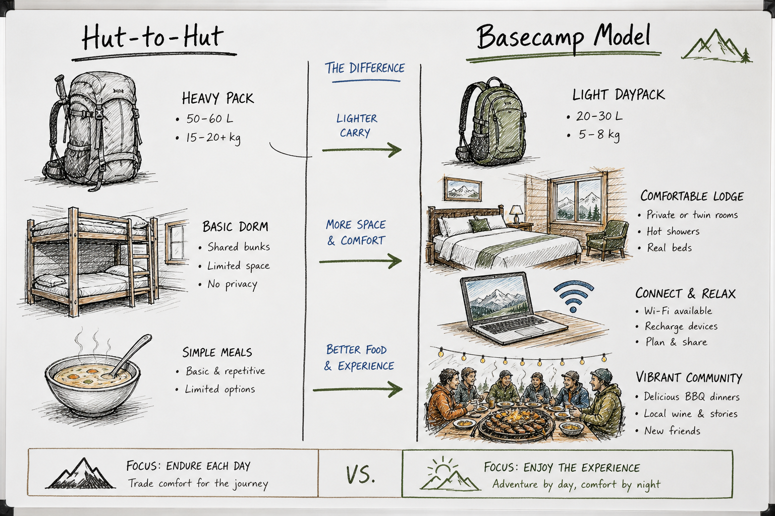
Switzerland offers two primary ways to structure a hiking trip: the traditional hut-to-hut trek, or the modern hub-and-spoke basecamp model.
The Traditional Hut System (SAC Huts)
Hut hiking in Switzerland is an iconic experience. The Swiss Alpine Club (SAC) operates over 150 mountain refuges situated at high altitudes.
- Pros: You get to sleep above the tree line, experience alpine sunrises, and link together massive distances without descending to the valley floor.
- Cons: You must carry all your daily gear, huts offer very limited privacy (mostly large dormitories), amenities like showers and Wi-Fi are rare or non-existent, and the repetitive diet of bread, cheese, and basic stews can become monotonous.
The Hub-and-Spoke Basecamp Model
For digital nomads, solo travelers wanting a vibrant social scene, or budget-conscious hikers trying to avoid the high cost of individual mountain transports, the basecamp model is highly efficient.
- How it Works: You book a long-term stay at a centrally located lodge, unpack your bags once, and take day trips (via train, bus, or organized transport) to different trailheads.
- The Vibe: Places like Ski Hostel in the Swiss Alps are built specifically around this concept. Instead of transactional hotel stays, they curate weekly adventure programs. Logistics, equipment rentals, and group itineraries are managed by hosts and volunteers.
- The Benefits: You can work remotely on fast Wi-Fi during down days, socialize at communal dinners, and pivot your hiking plans easily if bad weather hits one valley but not another.
Budget Logistics: Navigating the Alps Affordably
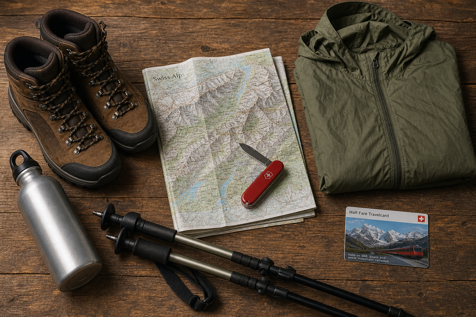
Switzerland’s public transport is flawless but expensive. If you are planning to hit multiple routes on this list, do not buy individual point-to-point tickets.
- The Half-Fare Card (Halbtax): This is the holy grail for budget hikers. For a flat monthly fee, it gives you 50% off almost all trains, buses, and mountain cable cars in the country.
- The Swiss Travel Pass: Best if you are moving long distances every single day. It offers unlimited transit on trains and buses, but note that it usually only gives a 25% to 50% discount on high-mountain gondolas.
- Supermarket Lunches: Coop and Migros are the two dominant Swiss supermarkets. They offer robust bakery sections and pre-made trail meals. Buying your lunch here instead of at a mid-mountain restaurant will save you roughly 30 CHF per day.
For a deeper dive into financial strategies for your trip, read our complete guide on 7 Tips for Hiking in Switzerland (Without the High Cost).
Frequently Asked Questions
When is the best time to hike in Switzerland?
Mid-July through late September is the optimal window. Before July, many trails above 2,000 meters are still blocked by dangerous snowfields or are too muddy to navigate safely. By October, the first snows begin to fall, and mountain transport systems begin shutting down for pre-winter maintenance.
Do I need a professional guide for these routes?
For the beginner and intermediate routes listed above, no. The trails are heavily trafficked and expertly marked. For advanced routes like the Hardergrat or glacier crossings, a guide is strongly recommended if you do not have prior high-alpine experience.
Are the hiking trails heavily crowded?
It depends entirely on the region and the time of day. The Eiger Trail, Zermatt’s 5 Lakes, and Oeschinensee will be very busy between 10:00 AM and 3:00 PM. To escape the crowds, start your hikes at dawn, or explore deeper, lesser-known valleys like Val de Bagnes or St. Stephan where community-focused lodges sit closer to untouched wilderness.