Safest hiking trails in the Swiss Alps for solo travelers
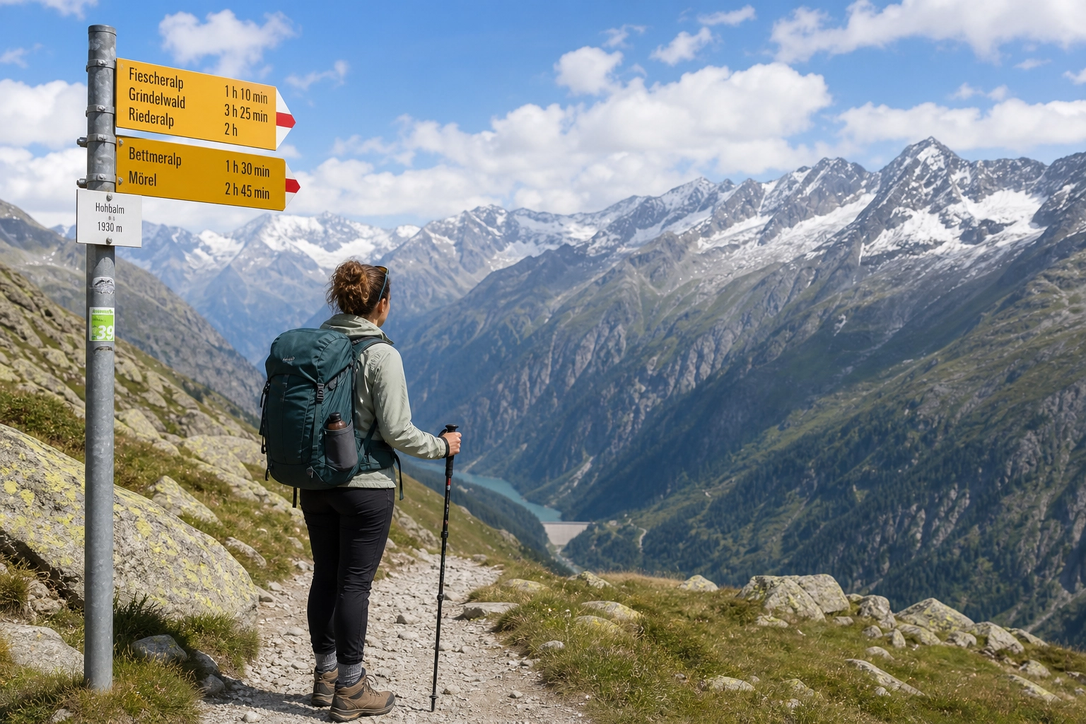
Switzerland offers some of the most dramatic mountain scenery on earth, supported by a world-class network of public transit, marked footpaths, and alpine huts. For solo travelers, backpackers, and digital nomads, hitting the trails independently presents an incredible sense of freedom. However, high-altitude terrain brings genuine risks: sudden weather shifts, loose scree, steep drop-offs, and physical exhaustion.
Navigating the Alps safely as a solo hiker does not require sacrificing adventure. It requires choosing routes with low terrain hazard, reliable transit escape routes, constant cell service, and predictable trail conditions. By understanding Switzerland’s standardized trail grading system, picking well-trafficked paths, and utilizing local transit infrastructure, you can experience breathtaking alpine views without taking uncalculated risks.
This guide breaks down the safest hiking trails in the Swiss Alps for solo travelers, how to read official Swiss trail signposts, mandatory digital tools, and practical safety protocols to keep your solo journey secure.
Decoding Swiss Trail Ratings: What Solo Hikers Must Know
Switzerland maintains over 65,000 kilometers of marked footpaths, managed under a uniform classification system established by the Swiss Alpine Club (SAC). Understanding these official trail ratings is your first line of defense when hiking alone.
Trail signposts in Switzerland are color-coded. Each color corresponds directly to the technical difficulty, required footwork, and exposure level of the path.
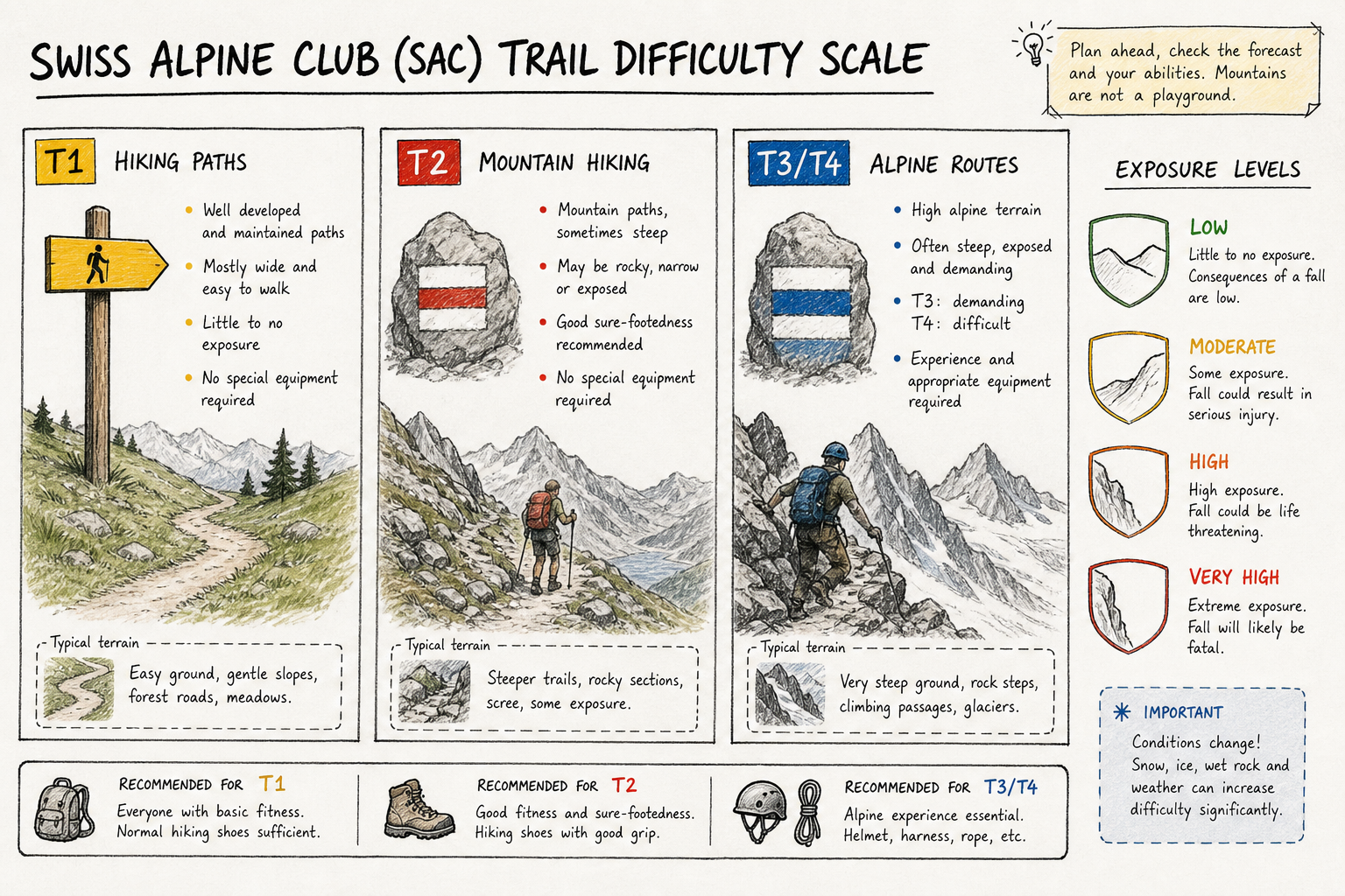
Yellow Trail Markers (T1 - Hiking Trails)
Yellow signposts indicate wide, well-maintained paths with minimal elevation gain and zero fall exposure. These trails are fully accessible in standard walking shoes or lightweight trainers. They are ideal for warm-up days, recovery sessions, or hikers who prefer flat, paved, or hard-packed gravel walking routes.
Red-White-Red Trail Markers (T2/T3 - Mountain Trails)
Red-white-red painted flashes on rocks, trees, and signposts signify official mountain hiking routes (Bergwanderwege). These paths are narrow, steep in sections, and often traverse uneven rocky terrain.
- T2 (Mountain Hiking): Continuous trail, sure-footedness recommended, minimal exposure. Perfect for fit solo hikers with proper ankle-support boots.
- T3 (Challenging Mountain Hiking): Exposed drop-offs, loose scree, and sections assisted by fixed ropes or chains. Solo hikers should approach T3 routes with caution and avoid them during rain or low visibility.
Blue-White-Blue Trail Markers (T4-T6 - Alpine Routes)
Blue-white-blue markers designate technical alpine routes (Alpinwanderwege). These trails frequently cross glaciers, unexposed ridges, or vertical rock faces requiring scramble skills, helmets, ropes, or crampons. Unaccompanied solo hikers should avoid T4-T6 routes unless they hold formal mountaineering certification and carry satellite rescue beacons.
Summary of SAC Trail Classifications for Solos
| SAC Level | Marker Color | Terrain Description | Solo Hiker Recommendation |
|---|---|---|---|
| T1 (Walking) | Yellow | Wide, flat, hard-packed earth or pavement. | Safe for all skill levels. |
| T2 (Mountain Hiking) | Red-White-Red | Steep, uneven dirt/rock footpaths; clear route marking. | Ideal for fit, prepared solo hikers. |
| T3 (Challenging) | Red-White-Red | Exposed ridges, cables, steep scree patches. | Use caution; avoid when wet or alone. |
| T4-T6 (Alpine) | Blue-White-Blue | Technical rock, glaciers, severe exposure, no clear trail. | Avoid solo without guide or alpine skills. |
Top 7 Safest Hiking Trails in the Swiss Alps for Solo Travelers
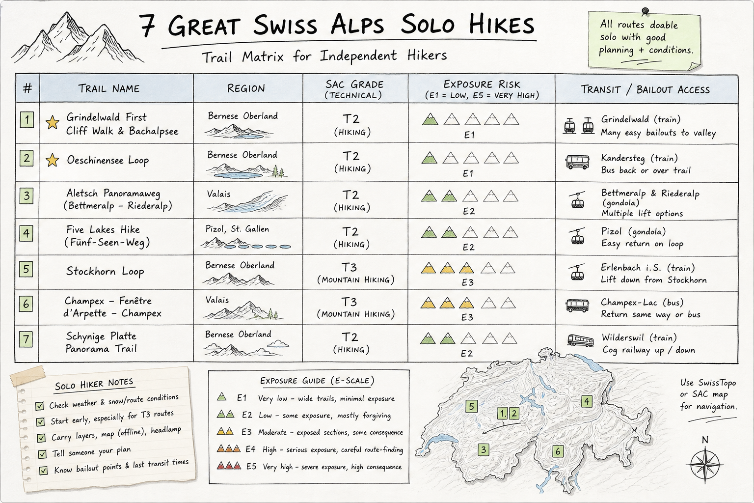
The following seven routes balance spectacular scenery with high safety factors: clear SAC T1/T2 ratings, high foot traffic, strong mobile coverage, and proximity to cable cars or trains for fast transit bailouts.
1. Mürren to Gimmelwald (Bernese Oberland)
- Distance: 3.0 km (one way)
- Elevation Gain: 10 m / Loss: 300 m
- SAC Grade: T1
- Transit Access: Cable cars at both Mürren and Gimmelwald
- Why it is safe for solo hikers: This gentle downhill stroll connects two car-free cliffside villages in the Jungfrau region. The path is paved or gravel, surrounded by flower-filled meadows with constant views of the Eiger, Mönch, and Jungfrau peaks. Because the route sees steady walk traffic, you are never far from assistance or a cafe.
2. Lake Bachalpsee from First (Grindelwald)
- Distance: 6.0 km (round trip)
- Elevation Gain: 180 m
- SAC Grade: T1 / T2
- Transit Access: Grindelwald-First gondola terminal
- Why it is safe for solo hikers: The trail from First gondola station to Lake Bachalpsee is one of Switzerland’s most popular alpine walks. According to community guidance on MySwissAlps, this path offers wide, double-track dirt trails, high visibility, and exceptional safety for solo female hikers and first-time alpine visitors. If mountain weather deteriorates, the return path leads directly to the covered cable car terminal.
3. Oeschinensee Panorama Loop (Kandersteg)
- Distance: 8.5 km (loop)
- Elevation Gain: 420 m
- SAC Grade: T2
- Transit Access: Kandersteg cable car
- Why it is safe for solo hikers: Lake Oeschinen is renowned for its bright turquoise waters framed by sheer vertical cliffs. The classic upper loop stays on well-graded earth paths lined with wooden handrails in exposed spots. High daily visitor numbers mean you will share the route with fellow outdoor enthusiasts, ensuring help is nearby if you trip or need directions.
4. Riffelsee to Riffelberg via Rotenboden (Zermatt)
- Distance: 3.2 km (one way)
- Elevation Gain: 50 m / Loss: 280 m
- SAC Grade: T2
- Transit Access: Gornergrat cogwheel train stations at Rotenboden and Riffelberg
- Why it is safe for solo hikers: Located high above Zermatt, this short downhill walk offers mirror reflection views of the Matterhorn in Lake Riffelsee. The route runs parallel to the Gornergrat mountain railway line. If fatigue or altitude headaches strike, you are never more than 20 minutes from a train station equipped with heated waiting rooms.
5. St. Stephan to Simmenfälle (Simmental Valley)
- Distance: 11.5 km (one way)
- Elevation Gain: 150 m
- SAC Grade: T1
- Transit Access: Regional train stops along the Simmental railway line
- Why it is safe for solo hikers: Situated in the tranquil Bernese Oberland, this valley floor path follows the crystal-clear Simme River from St. Stephan toward the roaring Simmenfälle waterfalls. It avoids steep high-alpine drop-offs completely while delivering authentic wooden chalet architecture, lush pine forests, and alpine meadows. Train stations along the route allow you to adjust your hike distance on the fly.
6. Lac de Champex Shoreline & Val Ferret Routes (Valais)
- Distance: 5.0 to 10.0 km (variable loop options)
- Elevation Gain: 100 to 300 m
- SAC Grade: T1 / T2
- Transit Access: PostBus stops at Champex-Lac and Orsières
- Why it is safe for solo hikers: The Valais region around Champex-Lac offers pristine sub-alpine hiking along historic irrigation channels (bisses) and mountain lakes. These routes feature gradual grades, rich tree cover protecting hikers from high winds, and frequent alpine bakeries. If you want to explore deeper routes nearby, check out our guide on the 5 Best Hiking Trails in Switzerland Near Mont Blanc.
7. Val de Bagnes Bisse du Levron Walk (Verbier Region)
- Distance: 9.0 km (one way)
- Elevation Gain: 80 m / Loss: 350 m
- SAC Grade: T2
- Transit Access: Les Ruinettes cable car station
- Why it is safe for solo hikers: Following a 15th-century mountain water channel, the Bisse du Levron contour line trail provides high-altitude views across the Pennine Alps without strenuous uphill climbing. The path is flat, clearly signposted, and terminates near mountain restaurants with swift gondola transport down to Verbier.
Comparison of Solo-Friendly Alpine Routes
| Trail Name | Region | Distance | Distance / Time | Exposure Risk | Transit Escape Route |
|---|---|---|---|---|---|
| Mürren to Gimmelwald | Bernese Oberland | 3.0 km | 1.0 hr | None | Cable car at start/finish |
| Lake Bachalpsee | Grindelwald | 6.0 km | 2.0 hrs | Very Low | Gondola at First terminal |
| Oeschinensee Loop | Kandersteg | 8.5 km | 3.5 hrs | Low (protected rails) | Gondola at Kandersteg |
| Riffelsee to Riffelberg | Zermatt | 3.2 km | 1.2 hrs | Very Low | Gornergrat train stations |
| St. Stephan Valley Trail | Simmental | 11.5 km | 3.0 hrs | None | Regional train network |
| Lac de Champex Loop | Valais | 5.0 km | 1.5 hrs | None | PostBus network |
| Bisse du Levron | Valais / Verbier | 9.0 km | 2.5 hrs | Low | Les Ruinettes cable car |
The Tech Stack for Alpine Safety: Recommended Apps
Navigating solo requires reliable digital backup. Cell coverage across the Swiss Alps is surprisingly comprehensive, even on high passes. Having the right mobile applications installed and cached before leaving your lodge ensures smooth navigation and fast emergency response.
As highlighted by Alpine Hikers, pairing real-time transport applications with local weather radar creates an effective safety net for solo travelers.
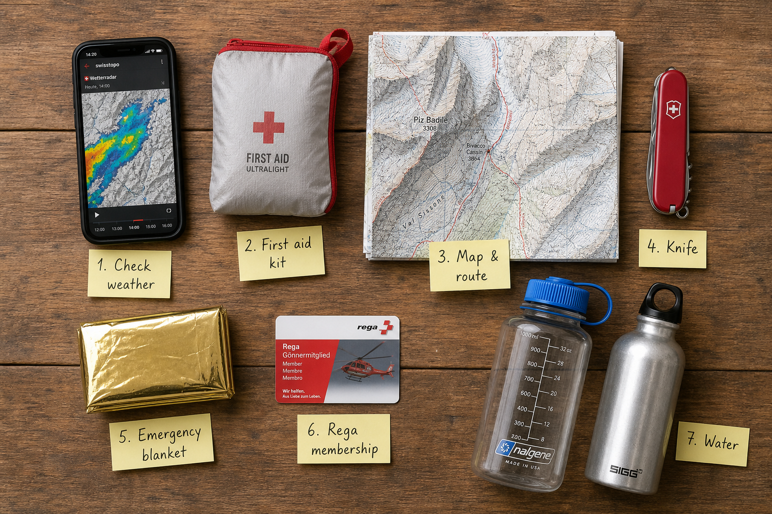
1. Swisstopo (Official Map App)
Swisstopo is the official vector mapping tool of the Swiss Federal Office of Topography. It is arguably the most precise mapping app available for outdoor enthusiasts worldwide.
- Key Feature: Download official 1:25,000 scale topographic maps for offline use.
- Safety Benefit: Displays exact SAC trail network color overlays (yellow, red, blue) and tracks your real-time GPS location relative to terrain contours.
2. SBB Mobile (Swiss Federal Railways)
Public transit is Switzerland’s greatest safety valve for solo hikers. The SBB app integrates trains, postal buses (PostBus), city trams, and mountain cable cars into one seamless interface.
- Key Feature: Live door-to-door timetable tracking.
- Safety Benefit: If afternoon storms roll in or you twist an ankle, SBB shows the nearest bus stop or cable car departure within seconds, allowing immediate bailout.
3. MeteoSwiss (Official Weather Radar)
Alpine weather changes rapidly. Clear morning skies can turn into violent lightning storms by 2:00 PM. MeteoSwiss provides localized forecasts powered by Swiss weather radar networks.
- Key Feature: High-resolution zoomable precipitation radar and storm warning alerts.
- Safety Benefit: Check the live rain animation before ascending exposed ridges. If red storm cells approach your grid square, turn back early.
4. Rega (Swiss Air Rescue App)
SWR Rega operates Switzerland’s air rescue helicopter system. The Rega application is built specifically for remote emergency signaling.
- Key Feature: One-tap emergency alarm activation.
- Safety Benefit: Pressing the emergency button inside the app automatically transmits your precise geographic coordinates directly to the Rega dispatch center, even if voice signals are weak.
Essential Solo Safety Protocol & Packing Checklist
Before taking your first step onto a Swiss trail alone, establish a disciplined safety routine. Small preparation habits prevent minor setbacks from becoming serious wilderness rescues.
The 5-Step Solo Trail Protocol
- Share Your Flight Plan: Never leave your accommodation without informing someone of your intended route, planned return time, and backup options. Share your route via WhatsApp or leave a quick note at your lodge front desk.
- Check the Live Webcams: Swiss mountain stations operate 24/7 webcams. Before taking a morning train, check mountain summit webcams to confirm fog, cloud base height, and snow conditions.
- Set a Hard Turn-Around Time: Determine an absolute cutoff time (e.g., 2:00 PM) to start your descent, regardless of whether you have reached your destination. Alpine lightning hazards peak in late afternoon.
- Monitor Battery Consumption: Cold mountain air accelerates smartphone battery drain. Carry a 10,000 mAh portable power bank and keep your phone inside an inner jacket pocket to conserve warmth.
- Carry Cash (CHF): While digital payments are widespread, remote mountain huts (Cabanen) often operate cash-only systems for water, snacks, or emergency shelter fees.
Mandatory Daypack Packing List for Solo Hikers
- Ankle-support waterproof hiking boots
- Layered clothing: merino wool base, fleece mid-layer, waterproof/windproof shell jacket
- Thermal emergency space blanket (lightweight foil)
- Compact first aid kit (blister plasters, sterile gauze, elastic bandage, ibuprofen)
- Minimum 1.5 liters of water and water purification tablets
- High-calorie snacks (nuts, energy bars, Swiss chocolate)
- Fully charged power bank and charging cable
- Printed copy or offline download of your route map
- Whistle and small headlamp (for emergency signaling)
To ensure your kit is completely dialed in without overpacking, read our complete breakdown on Swiss Alps Summer: A Simple 5-Step Packing Guide.
Real Scenario: Navigating Sudden Weather Shifts in Valais
To understand how these tools work together in practice, consider the experience of Marco, a digital nomad who spent three weeks solo hiking in Switzerland.
While tackling a T2 trail above the Valais valley, Marco noticed dark clouds forming over the surrounding peaks around 1:15 PM. Although his weather app originally forecasted clear skies until evening, opening the MeteoSwiss live radar revealed a localized thunderstorm cell forming rapidly over the mountain pass directly ahead of his path.
Rather than pushing forward to finish his planned loop, Marco executed a quick bailout plan:
- He opened Swisstopo to identify the nearest descending trail branch marked with yellow signposts.
- He checked SBB Mobile and found a PostBus departure from a village lower in the valley 45 minutes away.
- He messaged his hostel group chat to notify them of his modified route.
Marco reached the village stop just as heavy rain began to fall, boarding the bus safely without ever being exposed to lightning on the ridge. Having instant access to live transit schedules and offline maps transformed a potentially dangerous encounter with alpine weather into an easy afternoon transfer back to his base camp.
Myth-Busting: Solo Hiking Does Not Mean Hiking in Isolation
A common misconception among solo travelers is that choosing an independent mountain holiday requires total isolation on the trail. Many fear they must choose between expensive private tours or solitary wilderness camping.
In reality, Switzerland offers flexible middle ground: combining independent day hikes with social base camps.
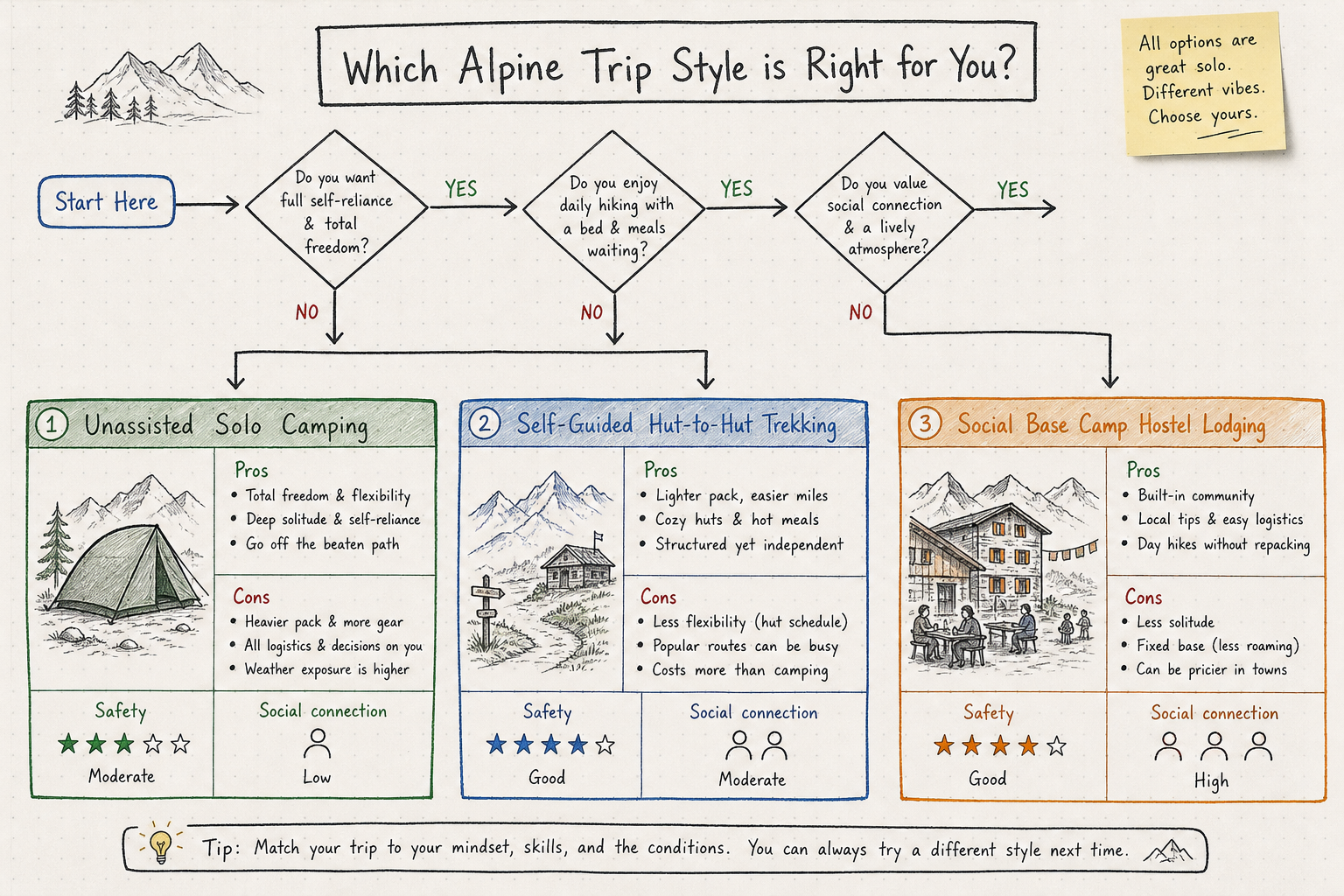
Comparing Solo Trekking Options
| Accommodation & Trip Style | Safety Factor | Social Connection | Planning Effort | Cost Level |
|---|---|---|---|---|
| Wild Camping / Unassisted Solo | Low (isolated emergencies) | Very Low | Very High | Low |
| Self-Planned Hut-to-Hut | Moderate (weather windows) | Moderate (communal dining) | High | Mid-to-High |
| Social Base Camp Hostel | Very High (daily trail updates & staff) | High (fellow hikers) | Low (transfers included) | Budget-Friendly |
Staying at a dedicated mountain hostel or social lodge provides the ultimate safety net for independent travelers. Base camps like Hiking Hostel in Liddes (Valais) or St. Stephan (Bernese Oberland) combine affordable accommodation with structured social support:
- Daily Trail Intelligence: On-site hosts review morning weather conditions, offer custom trail advice, and verify your daily return plans.
- Shared Trail Transport: Organized daily shuttles drop you off at safe trailheads and pick you up at designated finishes.
- Instant Hiking Buddies: Meet fellow backpackers and solo travelers over communal dinners, allowing you to buddy up for more adventurous T2/T3 routes without booking costly private guides.
If you want to enjoy the freedom of solo travel while keeping costs low and safety high, check out our insights on 7 Tips for Hiking in Switzerland (Without the High Cost) and see why Hotels in Swiss Mountains? Why Social Lodges Beat Luxury is the preferred choice for smart outdoor travelers.
For those interested in multi-day hut routes, review our tips on How to Plan Hut to Hut Hiking in Switzerland (7 Tips) before booking remote alpine stays.
Managing Emergencies and Alpine Hazards on the Trail
Even on low-risk T1 and T2 footpaths, natural hazards exist. Knowing how to react to unexpected challenges keeps you in control.
Loose Scree and Steep Slopes
When crossing patches of loose gravel or scree, shorten your stride and keep your center of gravity low over your feet. Plant trekking poles firmly ahead of you to establish three points of contact at all times.
Snow Patches in Early Summer
In June and early July, high passes often retain lingering snowfields. Never walk across steep snow bridges over running water. If a snow patch feels icy or unmanaged, turn around rather than risk a uncontrolled slide.
Livestock Guard Dogs (Patous)
In rural Valais and Bernese Oberland, large white Alpine guard dogs protect sheep herds from predators.
- Do not panic, run, or wave your trekking poles.
- Stop walking, speak calmly, and allow the dog to identify you as a human.
- Slowly walk around the outside perimeter of the sheep herd, giving them wide berth.
Emergency Numbers to Save on Your Phone
- 1414: Rega (Swiss Air Rescue - direct operational center)
- 112: European General Emergency Line (works on any available network provider)
- 117: Swiss Police
- 144: Swiss Ambulance / Medical Emergencies
As confirmed by trail reports on Together in Switzerland, emergency service dispatchers in Switzerland speak fluent English, French, and German, removing language barriers during urgent situations.
Frequently Asked Questions (FAQs)
Is solo hiking safe for female travelers in Switzerland?
Yes, Switzerland consistently ranks as one of the safest countries in the world for solo female travelers. Crime rates on mountain trails and inside public transit networks are extremely low. Physical alpine hazards (weather and terrain) are the main factors to manage. Sticking to marked T1/T2 trails, sharing your daily itinerary with your hostel, and keeping your phone charged ensures a secure outdoor trip.
What month is safest for solo hiking in the Swiss Alps?
July, August, and early September offer the safest mountain conditions. During these mid-summer months, high passes are clear of winter snow, cable cars run on full daily schedules, alpine huts are open, and trail foot traffic is steady. Early June can present dangerous lingering snowpacks on high T2/T3 routes.
Do foreign travelers need specialized mountain rescue insurance?
Standard travel medical insurance often excludes high-altitude search and rescue operations. Joining Rega as a patron donor (around CHF 40 for an annual gift) or purchasing basic mountain rescue coverage ensures helicopter rescue costs are fully covered if an unexpected injury occurs on the trail.
How do I handle language barriers during emergencies on Swiss footpaths?
Swiss emergency services (112 and 1414) operate multi-lingual dispatchers who speak English, French, German, and Italian. Additionally, using the Rega app automatically sends your exact GPS coordinates digitally, eliminating the need to explain your location verbally if you do not speak the local language.
Plan Your Safe Solo Alpine Adventure
Hiking the Swiss Alps alone does not mean taking unnecessary risks. By selecting well-maintained T1 and T2 trails, utilizing apps like Swisstopo and SBB Mobile, packing essential safety gear, and staying connected through social base camps, you can explore Switzerland’s vertical landscapes with total confidence.
If you are planning your summer journey, join us at Hiking Hostel. Our week-long summer packages in Liddes and St. Stephan offer comfortable social lodging, homemade meals, airport transfers, daily trailhead transport, and organized excursions across Valais, Interlaken, and Mont Blanc. You get all the freedom of solo travel paired with the safety, camaraderie, and convenience of a passionate outdoor community.
For more trip planning resources, explore our articles on Guided Hiking in Switzerland: Finding Your Social Group or plan a scenic cross-border outing with our guide on Skiing in the Italian Alps? Try This Aosta Day Trip.